Category: Local Project Listing 2019

Read more

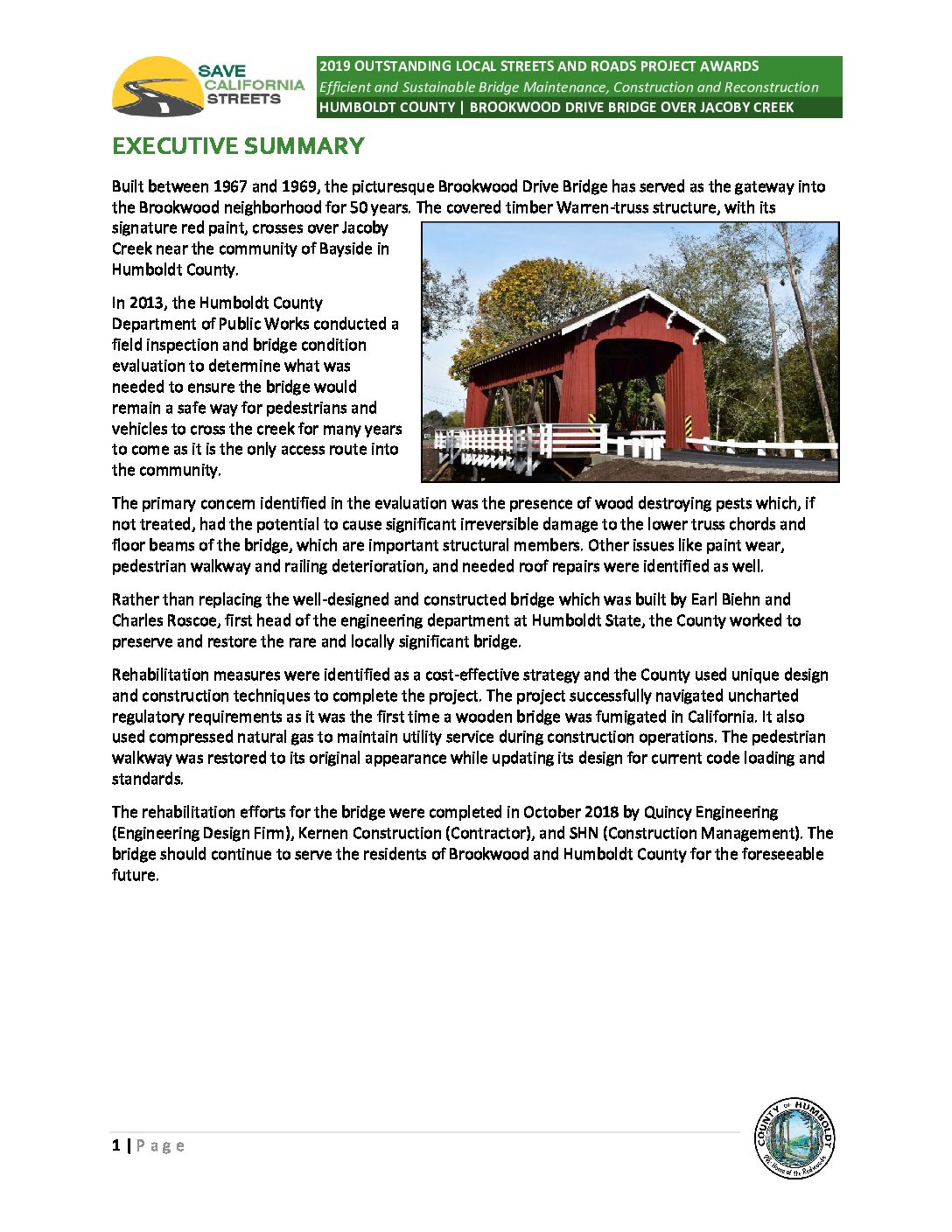
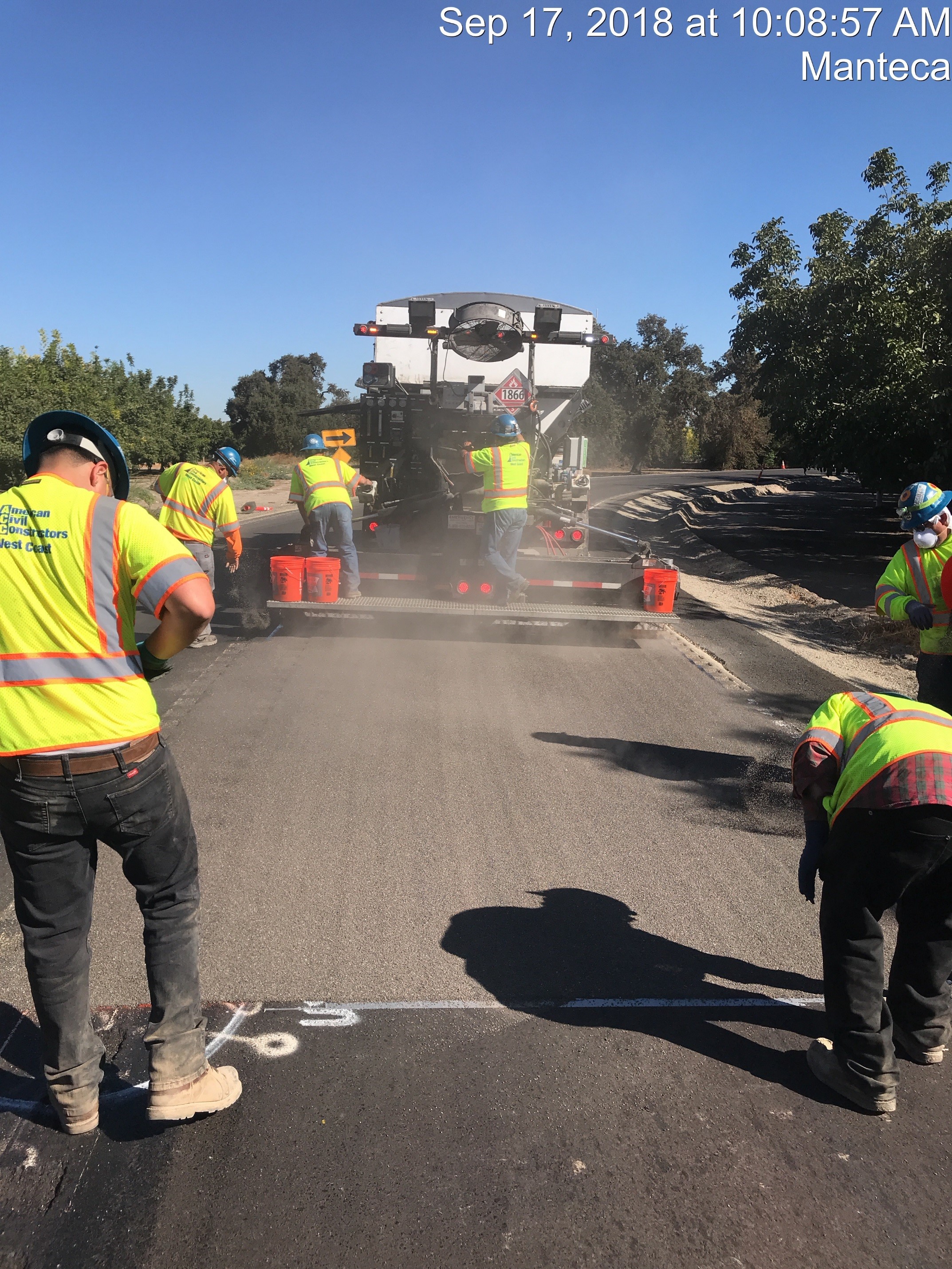
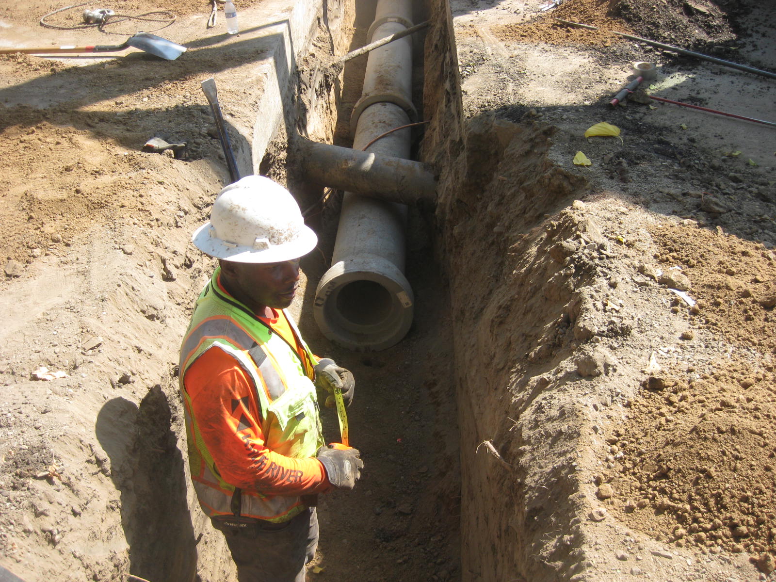
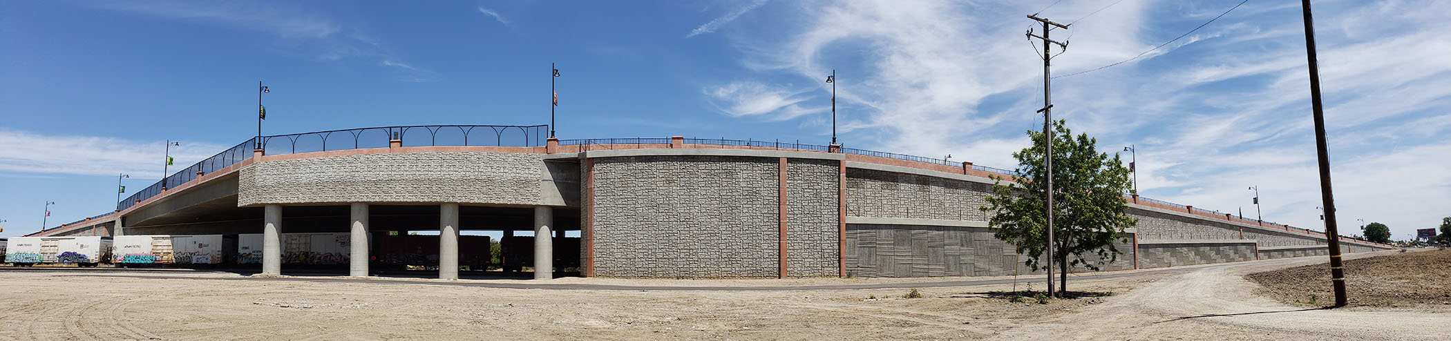
11th Street East Tracy Overhead Bridge Replacement

Location 11th Street and MacArthur Drive City or County Responsible for Project City of Tracy Category Bridge: Efficient and Sustainable Bridge Maintenance, Construction and Reconstruction Projects Author Zabih Zaca Organization City of Tracy Address 333 Civic Center Plaza, Tracy, CA 95376 Phone 209.831.6452 Project Description The 11th Street Bridge is a major thoroughfare in the City of Tracy. The original bridge provided vehicular access over three active Union Pacific Railroad tracks, but was too narrow to provide safe access for pedestrians and bicyclists. The recently completed 11th Street Bridge designed by Drake Haglan & Associates, Inc. provides wider traffic lanes, 4-foot median, 8-foot shoulders which also serve as Class II bicycle lanes, and barrier-separated mixed-use paths that promote the safe use across the UPRR tracks by pedestrians and bicyclists. The new bridge will assist the City in meeting their General Plan objective to achieve a comprehensive system of City-wide bikeways. […]

Read more

Brookwood Drive Bridge over Jacoby Creek Rehabilitation Project

Location Brookwood Drive and Jacoby Creek Road City or County Responsible for Project Humboldt County Category Bridge: Efficient and Sustainable Bridge Maintenance, Construction and Reconstruction Projects Author Tony Seghetti Organization Humboldt County Public Works Address 1106 Second Street, Eureka, CA 95501 Phone 707-445-7377 Project Description Built between 1967 and 1969, the picturesque Brookwood Drive Bridge has served as the gateway into the Brookwood neighborhood for 50 years. The covered timber Warren-truss structure, with its signature red paint, crosses over Jacoby Creek near the community of Bayside in Humboldt County. In 2013, the Humboldt County Department of Public Works conducted a field inspection and bridge condition evaluation to determine what was needed to ensure the bridge would remain a safe way for pedestrians and vehicles to cross the creek for many years to come as it is the only access route into the community. The primary concern identified in the evaluation […]

Read more

[Resubmitted] City of Riverside ITS Connectivity and Connected Vehicle Technology Initiatives

Location Magnolia and University Avenues within the City of Riverside City or County Responsible for Project Riverside Author Nathan Mustafa Organization City of Riverside Address 3900 Main Street Phone 9518262251 Project Description Magnolia Avenue spans nearly the entire length of the City of Riverside, linking major centers of commerce such as the Galleria at Tyler and Riverside Plaza, medical institutions such as the Kaiser Medical Center and Riverside Community Hospital, educational institutions including Cal Baptist University and Riverside City College, the Central Business District, our neighboring agencies, and State Routes 91 and 60. In November of 2018 10.5 miles of fiber optic cabling went ‘live’ along Magnolia Avenue, spanning 49 signalized intersections; a project funded through a combination of Federal CMAQ and State MSRC grant dollars. This project has enabled Riverside to deploy additional traffic monitoring cameras, rapidly deploy and adjust traffic signal timing and coordination plans, and sets the […]

Read more

City of Riverside ITS Connectivity and Connected Vehicle Technology Initiatives

Location Magnolia and University Avenues within the City of Riverside City or County Responsible for Project Riverside Author Nathan Mustafa Organization City of Riverside Address 3900 Main Street Phone 9518262251 Project Description Magnolia Avenue spans nearly the entire length of the City of Riverside, linking major centers of commerce such as the Galleria at Tyler and Riverside Plaza, medical institutions such as the Kaiser Medical Center and Riverside Community Hospital, educational institutions including Cal Baptist University and Riverside City College, the Central Business District, our neighboring agencies, and State Routes 91 and 60. In November of 2018 10.5 miles of fiber optic cabling went ‘live’ along Magnolia Avenue, spanning 49 signalized intersections; a project funded through a combination of Federal CMAQ and State MSRC grant dollars. This project has enabled Riverside to deploy additional traffic monitoring cameras, rapidly deploy and adjust traffic signal timing and coordination plans, and sets the […]

Clean-Up and Repair of Transportation Infastructure, Montecito Debris Flow, Januiary 2018

Location Montecito, California City or County Responsible for Project Santa Barbara County Category Safety or Intelligent Transportation System Projects Author Bill Tracy Organization Department of Public Works, County of Santa Barbara Address 4417 Cathedral Oaks Road Phone 805-681-5694 Project Description Clean-up and Repair of Transportation Infrastructure Damage Montecito Flood, January 2018 County of Santa Barbara, Department of Public Works January 10, 2019 Clean-up and Repair of Transportation Infrastructure Damage Montecito Flood, January 2018 County of Santa Barbara, Department of Public Works January 10, 2019 Introduction On January 9, 2018 an atmospheric storm of tremendous intensity passed thru Santa Barbara County. A radar image of the storm is presented in Figure 1-Intense Storm located just to the east of Santa Barbara in the community of Montecito. Several cloudbursts began dropping rainfall at 3:34 AM at the rate of one-half inch of rain in 5 minutes, according to the County Flood Control […]

Read more

State Route 92/State Route 82 Interchange Upgrade

Location State Route 92/State Route 82, San Mateo, California City or County Responsible for Project City of San Mateo Category Roads: Efficient and Sustainable Road Maintenance, Construction and Reconstruction Projects. Author Kellie Benz Organization City of San Mateo – Public Works Department Address 330 W. 20th Avenue Phone 650-522-7282 Project Description The City of San Mateo has experienced unprecedented growth in recent years thanks largely to its proximity to Silicon Valley. To ensure intelligently managed roads, the city prioritized the upgrade of one of its busiest connectors: State Route 92/State Route 82 Interchange. Work was completed in 2018. The Interchange was a classic cloverleaf marking the middle of the city. Originally named the Route 105/Route 2 Separation, the Interchange was built in 1961/62 when city population was 69,000. In 2016, city population was just over 103,000. The Interchange connects eastbound SR 92 to Eastbay counties and westbound SR 92 to […]

Century Boulevard Extension from Grape Street to Alameda Street

Location Grape Street and Century Boulevard City or County Responsible for Project City of Los Angeles Category Complete Streets Projects Author Ramnik D. Mungra Organization Engineering, City of Los Angeles Address 1149 S. Broadway, Suite 810, Los Angeles, CA 90015 Phone 213-485-4526 Project Description As part of the Jordan Downs Redevelopment in the Watts Community of Los Angeles, the Century Boulevard Extension Project extended Century Boulevard from Grape Street to Alameda Street. Century Boulevard was designed and constructed as a neighborhood “Main Street” consistent with the Jordan Downs Urban Village (JDUV) Specific Plan. The project constructed a multimodal roadway where no streets, bike lanes, sidewalks, or pedestrian enhancements previously existed. This half-mile roadway serves as the spine of a 119-acre mixed use redevelopment connecting 1,800 residential units, open spaces, community facilities, and retail spaces while promoting sustainability and alternatives to car ridership by providing bus access, bike lanes, sidewalks, and […]

Read more

Austin Road Safety Improvements and French Camp Road Safety Improvements

Location Austin Road from French Camp road to Burnham Road; French Camp Road from Prescott Road to Jack Tone Road City or County Responsible for Project San Joaquin County Category Safety or Intelligent Transportation System Projects Author Kris Balaji Organization San Joaquin County Department of Public Works Address 1810 E. Hazelton Avenue Phone (209) 468-3000 Project Description San Joaquin County Department of Public Works utilizes a traffic collision database to help identify locations where improvements can be made to enhance safety for the traveling public. Through ongoing vigilance to improve safety, county engineers identified two roadways, Austin Road and French Camp Road, as having multiple collisions with similar factors. Based on the review of county engineers, it was determined that placement of High-Friction Surfacing (HFS) would be appropriate at these two locations. Consequently, county engineers applied for and received Highway Safety Improvement Program (HSIP) funding for the two roadway projects. […]

Read more

Cherokee Road Improvements

Location Cherokee Road from Sanguinetti Lane to Diverting Canal City or County Responsible for Project San Joaquin County Category Complete Streets Projects Author Kris Balaji Organization San Joaquin County Department of Public Works Address 1810 E. Hazelton Avenue Phone (209) 468-3000 Project Description Prior to improvements by San Joaquin County, Cherokee Road was a challenging area to travel through not only for vehicles but pedestrians as well. Development of the area dates back to the 1940s and 1950s, when few standards existed. Prior to the project, the pavement surface was in poor condition, rutted and riddled with cracks. The roadway also lacked an integrated storm drainage system, as only some portions had rudimentary drain inlets and intermittent roadside ditches. Other areas simply pooled or drained into the surrounding properties. Additionally, the corridor lacked pedestrian facilities despite the high volume of pedestrian traffic in the area including: schoolchildren; business patrons; and […]

Read more

Lammers Road Pedestrian Pathway

Location Lammers Road between Redbridge Road and Kimball High School City or County Responsible for Project San Joaquin County Category Safety or Intelligent Transportation System Projects Author Kris Balaji Organization San Joaquin County Department of Public Works Address 1810 E. Hazelton Avenue Phone (209) 468-3000 Project Description When faced with the challenge of providing a 0.6 mile pathway for area school students with only a little over two months before school was scheduled to begin, San Joaquin County engineers had to think fast. In order to provide the pathway along Lammers Road between an isolated residential area, Redbridge, and the newer Kimball High School in the City of Tracy, San Joaquin County, in collaboration with the City, took a unique approach and constructed a base rock path to allow students to walk or bike to and from the high school. This met the immediate need before school started, and allows […]

Account details will be confirmed via email.