Category: Local Project Listing 2023

Read more

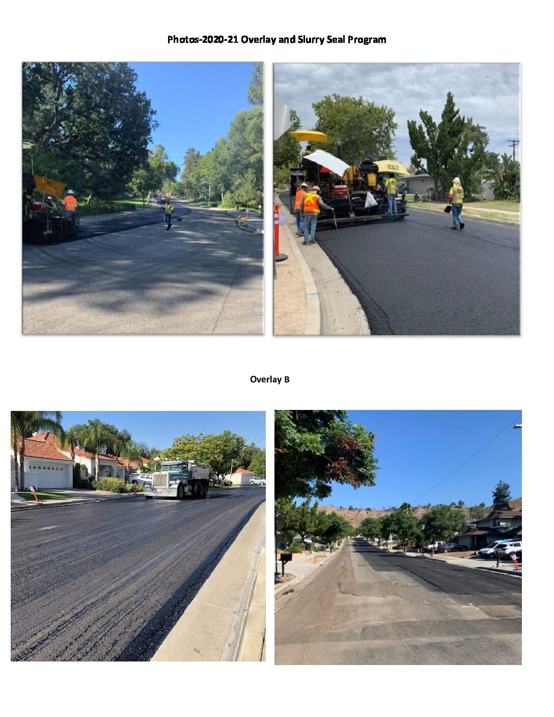
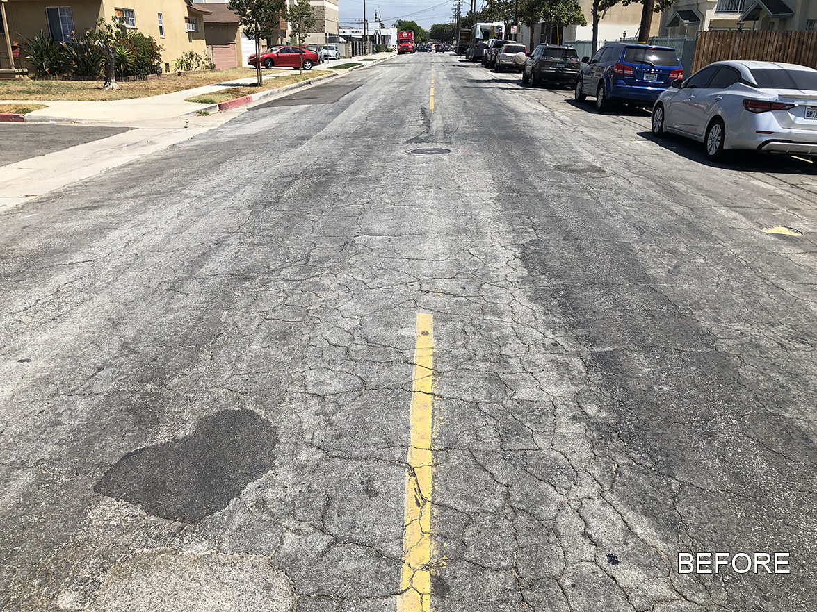
Paving the Way – Phase 2 and HyRAP Streets Project

Location Various Locations City or County Responsible for Project City of Montebello Category Roads: Efficient and Sustainable Road Maintenance, Construction and Reconstruction Projects. Author René Bobadilla, P.E. Organization City of Montebello Address 1600 West Beverly Boulevard, Montebello, CA 90640-3932 Phone (323) 887-1350 Project Description MONTEBELLO – BRINGING SUSTAINABLE STREETS TO OUR RESIDENTS Cities throughout Southern California struggle with aging streets, limited budgets and looming environmental mandates. Montebello recently confronted those challenges with two innovative street projects, repaving nearly 100 streets. Montebello became the first California city to use the advanced Composite Layering System process, HyRAP® Hot Mix Asphalt (HyRAP®) on an Asphalt-Rubber Aggregate Membrane (ARAM), referred to as HyRAM™. Conventional hot mix asphalt is a combination of virgin aggregate and liquid asphalt (oil), whereas HyRAP® is produced almost entirely using recycled asphalt and petroleum rejuvenators, therefore resulting in a reduction of 100% of virgin aggregate and up to 90% in […]

Read more

Downtown Streets Circulation Project Redding

Location Market Street at Yuba Street, Butte Street and Tehama Street City or County Responsible for Project City of Redding Category Complete Streets Projects Author Chuck Aukland, PE Organization City of Redding Address 777 Cypress Avenue, Redding, CA 96001 Phone (530) 245-7156 Project Description The City of Redding Downtown Streets Circulation Project is an exemplary local road transportation project that is the centerpiece of downtown transformation and revitalization in Redding, California. This project utilized Affordable Housing and Sustainable Communities grant funding from the California Department of Housing and Community Development to reintroduce a local road that had been closed to vehicular traffic since 1972 and improve the facilities to better serve the downtown area and new residents of affordable housing calling the area home. The reintroduction of Market Street and modifications to Butte Street and Yuba Street not only reintroduced vehicle traffic to the area, but improved pedestrian and cyclist […]

Read more

City of San Jose 2021 ADA Curb Ramp Request Project #2 – Sustainable Mix Design

Location San Jose (various) City or County Responsible for Project City of San Jose Category Roads: Efficient and Sustainable Road Maintenance, Construction and Reconstruction Projects. Author Irene Ding Organization City of San Jose Address 1404 Mabury Rd, San Jose, CA 95133 Phone 415-816-2382 Project Description The City of San José’s “2021 ADA Curb Ramp Request Project #2 – Sustainable Mix Design” was the City’s very first pilot project aimed at reducing the carbon footprint of its concrete construction activities. The project constructed/upgraded 94 concrete curb ramps to be ADA compliant in response to residents’ requests for improved sidewalk and street accessibility for wheelchair users and people with disabilities. The scope of work included the design and construction of curb ramps, including improving curb and gutter, and adjacent sidewalk. The City of San José collaborated with the California Nevada Cement Association and U.S. Concrete to develop a specification for low-carbon concrete […]

Read more

Sierra Highway Sidewalks

Location Sierra Highway between Sarabande Lane and Hillfield Lane City or County Responsible for Project City of Santa Clarita Category Complete Streets Projects Author Shannon Pickett Organization City of Santa Clarita, Capital Projects Division Address 23920 Valencia Blvd., Suite 300 Santa Clarita, CA 91355-2196 Phone 661-255-4968 Supporting Documentation https://savecaliforniastreets.org/wp-content/uploads/2023/02/2023-02-07_63e1a1100853c_BackupforSierraHwySidewalks.pdf Project Description Ensuring safe paths of travel along City sidewalks and enhancing pedestrian safety are goals of the City of Santa Clarita (City) 2025 strategic plan and Local Roadway Safety Plan. The Sierra Highway Sidewalks project supports those safety goals by constructing an uninterrupted path of travel between the Canyon Country Community Center and Skyline Ranch development. The path of travel along Sierra Highway was wildly different from one property to the next. Pedestrians transitioned between sidewalks, planters, gravel, driveways, front yards and parking lots. Accessing transit, shopping, schools, and residences required pedestrians to maneuver through different elevations, grades, and surfaces […]

Read more

Iron Horse Trail Gap Closure – Livermore

Location Isabel Avenue to Murrieta Boulevard City or County Responsible for Project City of Livermore Category Complete Streets Projects Author Roberto Escobar Organization City of Livermore Address 1052 South Livermore Ave Phone (925) 960-4532 Supporting Documentation https://savecaliforniastreets.org/wp-content/uploads/2023/02/2023-02-07_63e1a1021719a_IHTrailTrailLivermoreLocationMapandPics2-6-23.pdf Project Description This project is a major milestone that completed one-mile gap of the Iron Horse Trail between the easterly edge of Downtown Livermore and the City of Pleasanton and resulted in a connection of Iron Horse and other local trails to the interregional Iron Horse Trail network in all the cities of Contra Costa County. This trail was planned through Livermore and over the last 10 years Livermore constructed several internal segments along downtown that run parallel the Union Pacific railroad tracks and connect to Livermore’s Downtown Transit Center. The goal of connecting to the regional Iron Horse Trail network and provide a continuous active transportation corridor between Concord and Livermore was […]

Read more

Devlin Road and Vine Trail Extension Project

Location Devlin Road/Boone Drive to Green Island Road City or County Responsible for Project City of American Canyon Category Complete Streets Projects Author Erica Ahmann Smithies Organization City of American Canyon Address 4381 Broadway Street Phone 7076474366 Supporting Documentation https://savecaliforniastreets.org/wp-content/uploads/2023/02/2023-02-07_63e19ec66748b_2023DevlinRoadandVineTrailExtensionProject.pdf Project Description The significance of the Devlin Road project is that it’s the final segment of a 3.5 mile stretch from the City of American Canyon to Soscol Ferry Road at Highway 29/221. In addition, the project connects the Green Island Road Industrial Area and the Napa County Airport Industrial Area allowing for business to business drivers to move within the industrial area without needing to use the highway. The need for a parallel route during an emergency closure of Highway 29 was put into action as recent as January 2023 when the highway was closed due to flooding. Without this segment, a highway closure between South Kelly Road and […]

Read more

2020-21 Overlay and Slurry Seal Program

The City of Santa Clarita (City) is the third largest city in Los Angeles County, and as such we strive to maximize our resources to preserve our growing pavement infrastructure. We employ a five-year pavement management plan to strategize the locations and treatments for our pavement projects. Our multi-year pavement management plan utilizes current pavement management principals of doing the right thing to the right pavement at the right time (Federal Highway Administration). The City’s maintained pavement network consists of 1,252.09 lane miles and 112,164,467 square feet. Maintenance for our pavement network is prioritized using a critical point management approach which focuses on the rehabilitation and maintenance of streets above rather than below a critical point pavement condition index (PCI). Before this project, the City’s overall PCI was 70, but with all of the creative strategies we employ, the City’s overall PCI rating increased to 72 after completion. The City […]

Read more

James Bypass Overflow Bridges on Manning Avenue

James Bypass was a multiple bridge project executed using the accelerated bridge construction method in order to keep Manning open to trucks and traffic for as much of the project duration as possible. The foundations for the two new bridges were constructed under the existing bridges, and the road was closed down for only 35 total days to demolish the old bridges, construct the new bridges, and pave the roadway. Since there was a very limited amount of space under the bridges to construct the foundations, the girders were designed with footings that would rest on the abutments and pier caps. Unfortunately, while pre-casting the foundations, it was discovered that alternative designs needed to be considered because the original girder design wouldn’t work. A design was chosen that raised the elevation of the pier caps and abutments utilizing a secondary concrete pour. While it added to the necessary road closure […]

Read more

Green Tree Blvd. Extension Project

The Green Tree Extension is the final phase of a three-phase multi-jurisdiction regional project. The agencies involved with permitting and funding are the City of Victorville, the San Bernardino County Transportation Authority (SBCTA), the County of San Bernardino, and the Town of Apple Valley. The project was added to the City of Victorville General Plan Circulation Element in 1988 and an alignment study was completed in 1994. In 2008, the Town of Apple Valley started the environmental document for the regional corridor project. In 2016, design and the right of way acquisition started for the Green Tree Extension. In 2020, right of way was certified. The construction contract was awarded in March 2021. The project is scheduled to be complete in May 2023. The Green Tree Boulevard Extension Project will extend Green Tree Boulevard from Hesperia Rd. to Ridgecrest Rd./Yates Rd., for a distance of over one mile. Integral to […]

North Dinuba Infrastructure Improvements Project

The City of Dinuba received an award of $4,198,800 through the Community Development Block Grant (CDBG) program for the North Dinuba Infrastructure Improvements Project. The project has brought much needed sewer, storm drain facilities, street improvements and a pocket park to an underserved area of town that was previously annexed by the City of Dinuba. These improvements will greatly benefit the residents who reside within the project service area. Not only will this project provide these residents with better infrastructure and a new park, it will also improve the overall quality of life in the area. The project met the Low Moderate Area (LMA) National Objective and will benefit approximately 7,370 persons that reside within this project service area. The North Dinuba Infrastructure Improvements Project installed approximately 3,300 lineal feet of sewer main to serve the current residents within the Griggs Avenue neighborhood, Western Sky Mobile Home Park, and other […]

Account details will be confirmed via email.