Category: Nominations

Read more

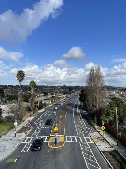
The Windsor River Road and Windsor Road Intersection Improvement and Multi-Use Pathway Connector Project

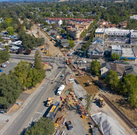
  Location Windsor River Road and Windsor Road City or County Responsible for Project Windsor Category Safety or Intelligent Transportation System Projects Description The Windsor River Road and Windsor Road Intersection Improvements and Multi‐Use Pathway Connector Project is a transformative transportation project with unique challenges but also substantial benefit for the community it serves. For this project, the Town of Windsor hired GHD to provide project planning, public outreach, permitting, grant assistance, design, and engineering services during construction. The scope of work included construction of a roundabout, at‐grade rail crossing safety devices, pedestrian crossing safety improvements, and a multi‐use pathway segment. The results of the project are improved safety, enhanced multi‐modal connectivity, environmental benefits, and a better sense of place and gateway into the downtown Town Green area. The roundabout design created safer active transportation infrastructure at a complex intersection. The new design is expected to reduce the number of […]

Read more

Loma Ridge Widening Project

  Location 2644 Santiago Cyn Rd, Silverado, CA 92676 City or County Responsible for Project Orange County CA Category Roads: Efficient and Sustainable Road Maintenance, Construction and Reconstruction Projects. Description The Loma Ridge Project (Project) widened approximately 5,600 feet of road leading to the County’s Emergency Operations Center (EOC) from one lane serving both directions to one lane in each direction. The EOC serves all Orange County residents to provide essential emergency services in the event of a catastrophe. Prior to completion of the Project, visibility in the area was low, the road had non-standard guard rails, above ground utilities in a high fire hazard area and poor quality pavement. The Project’s sustainable features included revegetation with a native hydroseed plant palette for any temporary impact areas, and an engineered filtration blanket for each roadway drainage outlet that included riprap, gravel, sand and geotextile designed to capture pollutants, maximize infiltration […]

Read more

Leland Avenue, et al., Street Improvement Project

  Location Unincorporated South Whittier City or County Responsible for Project Los Angeles County Category Roads: Efficient and Sustainable Road Maintenance, Construction and Reconstruction Projects. Description When it comes to street improvements, Los Angeles County Public Works has utilized sustainable pavement treatments with outstanding success. Public Works continues its commitment in preserving and improving the quality of our roads in a cost-effective and environmentally responsible way. California Mandate AB32 is a state law requiring the reduction of greenhouse gas (GHG) emissions and working within limited budgets were key motivators for developing Public Works’ sustainable approach which includes: (1) focusing on preserving roads in good condition; (2) using recycled materials in pavement treatments; and (3) reutilizing in-place materials during construction. The Leland Avenue, et al., Project that was completed in September 2023 showcases the benefits of Public Works’ sustainable approach. This project was funded with the Road Maintenance Rehabilitation Account funds. […]

Read more

Leong Drive and Fairchild Drive Reconstruction

  Location Leong Drive from Alamo Court to Fairchild Drive and Fairchild Drive from Leong Drive to 415 Fairchild Drive City or County Responsible for Project Mountain View Category Safety or Intelligent Transportation System Projects Description The Leong Drive and Fairchild Drive Reconstruction project was a pavement rehabilitation and bike/pedestrian infrastructure improvement project funded in part through Santa Clara County’s 2016 Measure B as well as City of Mountain View’s Capital Improvement Program. Leong Drive and Fairchild Drive are both heavily used neighborhood collector streets. Together, they serve as an important link between neighborhoods and regional job centers. Both streets were identified for pavement treatment due to poor pavement condition. This provided staff with an opportunity to deliver improved bike infrastructure as recommended in the City’s 2014 Bicycle Transportation Plan Update. There was no existing bicycle infrastructure on both streets that either deterred bicyclists from taking this route or leaded […]

Read more

Neighborhood Pavement Preservation & Arterial Pavement Repair Project

  Location Southport Parkway, Jefferson Blvd, Lake Washington Blvd City or County Responsible for Project City of West Sacramento Category Roads: Efficient and Sustainable Road Maintenance, Construction and Reconstruction Projects. Description The City of West Sacramento’s current Neighborhood Pavement Preservation Program & Arterial Streets Pavement Repair Program have been an important step in improving the condition, safety, and longevity of City’s roadway system. After many years of deferred maintenance on its road system, the City Council approved a Pavement Management Plan for the City. The Plan utilizes two programs: the Neighborhood Pavement Preservation Program which focuses on residential neighborhood streets and the Community Investment Program which focuses on arterial streets throughout the City. The Neighborhood Preservation Program focuses on preserving local roadways with the use of various seal coats. Staff has broken the City into ten areas for the Neighborhood Preservation Program and prioritized the areas to maximize the longevity […]

Read more

Regional Arterial Traffic Performance Measurement System (RATPeMS)

  Location The RATPeMS project has developed a Level of Service (LOS) model for 157 signalized intersections within the City of Glendale, creating an arterial traffic performance measurement system that allows for real-time operation timing.” This revision adds some clarity by specifying that the LOS model is for signalized intersections within the city and emphasizes the creation of the traffic performance measurement system. City or County Responsible for Project City of Glendale Category Safety or Intelligent Transportation System Projects Description The RATPeMS project has successfully developed a Level of Service (LOS) model for 157 signalized intersections within the city, transforming them into an advanced arterial traffic performance measurement system that enables real-time operation timing. Additionally, the project has implemented a cutting-edge fiber optic system called the State-of-the-Art Iteris Vantage Next video detection system at multiple locations, seamlessly connecting them to the City’s Traffic Management Center (TMC). This system provides real-time […]

Read more

Maintenance District 6 Pavement Rehabilitation Phase I Project

  Location City of Glendale Maintenance District 6 (citywide) City or County Responsible for Project City of Glendale Category Roads: Efficient and Sustainable Road Maintenance, Construction and Reconstruction Projects. Description The MD6 Phase I project consisted of removal and disposal of asphalt and Portland cement concrete (P.C.C.) pavements, including installation of: 0.4 miles of grinding and placement of Asphalt Rubber Hot Mix pavement (ARHM); 1.0 miles of ARHM over Asphalt Rubber Aggregate Membrane (ARAM system III); 1.1 miles of emulsion aggregate slurry (Slurry Seal Type II) over ARAM (ARAM System I); 2 miles of crack sealing material and emulsion aggregate slurry (Slurry Seal Type II). The project achieved safety, preservation, and sustainability goals because of the extensive work performed throughout the City’s Maintenance District. The project is a first for the City, in which various pavement treatment systems were implemented to improve the City’s Pavement Condition Index (PCI) which required […]

Read more

Rumrill Blvd. Complete Green Streets Project

  Location Rumrill Blvd. in San Pablo between Costa Ave. and San Pablo Ave. City or County Responsible for Project San Pablo Category Complete Streets Projects Description The City of San Pablo’s Rumrill Boulevard Complete Green Streets Project (the Project) is an overhaul of 1.67 miles of Rumrill Blvd. with elements that calm traffic, improve safety, reduce greenhouse gas emissions and improve stormwater quality. Specific improvements constructed as part of the Project include Class IV cycle tracks, street trees, green stormwater infrastructure (GSI), pavement striping, sidewalks, ADA curb ramps, flashing beacons, new traffic signal, signal interconnect cable technology, additional lighting, and improved transit stops. Rumrill Blvd. was previously negatively impacted by connectivity gaps and appropriate pedestrian, bicycle and stormwater infrastructure. These unsafe conditions hindered residents from accessing necessary services in both the cities of San Pablo and Richmond. Prior to this Project the street had two wide lanes of traffic […]

Read more

Broadway Rehabilitation Project

  Location Broadway, between Concord St and S. Central Ave City or County Responsible for Project City of Glendale Description The Broadway Rehabilitation Project involved the surface grinding and placement of approximately 0.6 centerline miles of ARHM; surface grinding and placement of approximately 0.3 centerline miles of ARHM over Asphalt Rubber Aggregate Membrane (ARAM); selective removal, repair, and reconstruction of approximately 4,300 linear feet of damaged curbs and gutters, and 28,300 square feet of sidewalks, driveways, cross gutters, alley aprons, and bus pads; modification and reconstruction of approximately 16 existing curb ramps to meet ADA standards. The project achieved safety, preservation, and sustainability goals because in addition to improving the approximate one mile stretch of a main arterial road in the City and in the heart of downtown Glendale, it also included multiple improvements that were relatively new to the City. Installation of reflective pavement, infiltration wells, creative crosswalks, and […]

Read more

Kirkwood Road and Columbia Avenue Bridges

  Location Over Jewett Creek just south of Corning, CA City or County Responsible for Project Tehama County Category Bridge: Efficient and Sustainable Bridge Maintenance, Construction and Reconstruction Projects Description Tehama County completed the new Kirkwood Road and Columbia Ave Bridges over Jewett Creek in December 2023. The old bridges were at the end of their service lives and both steel girder bridges were narrow with no shoulders. The Kirkwood Bridge was previously restricted to one lane due to the bridge’s condition. The new wider bridge at Kirkwood now has a 32-foot clear roadway width, while Columbia now has a 24-foot width. Both are now reinforced concrete slab type bridges and offer many advantages. These new bridges meet the function classification, terrain, and AASHTO standards; and provide safe and modern facilities for County residents and local agribusiness. Key design features provide service longevity, limited maintenance, and positive environmental effects including […]

Account details will be confirmed via email.