Miller Avenue Streetscape Plan
Location
Miller Avenue from Sunnyside to Almonte
City or County Responsible for Project
City of Mill Valley
Category
Complete Streets Projects
Author
Andrew Poster
City of Mill Valley
26 Corte Madera Avenue
(415) 384-4800
Project Description
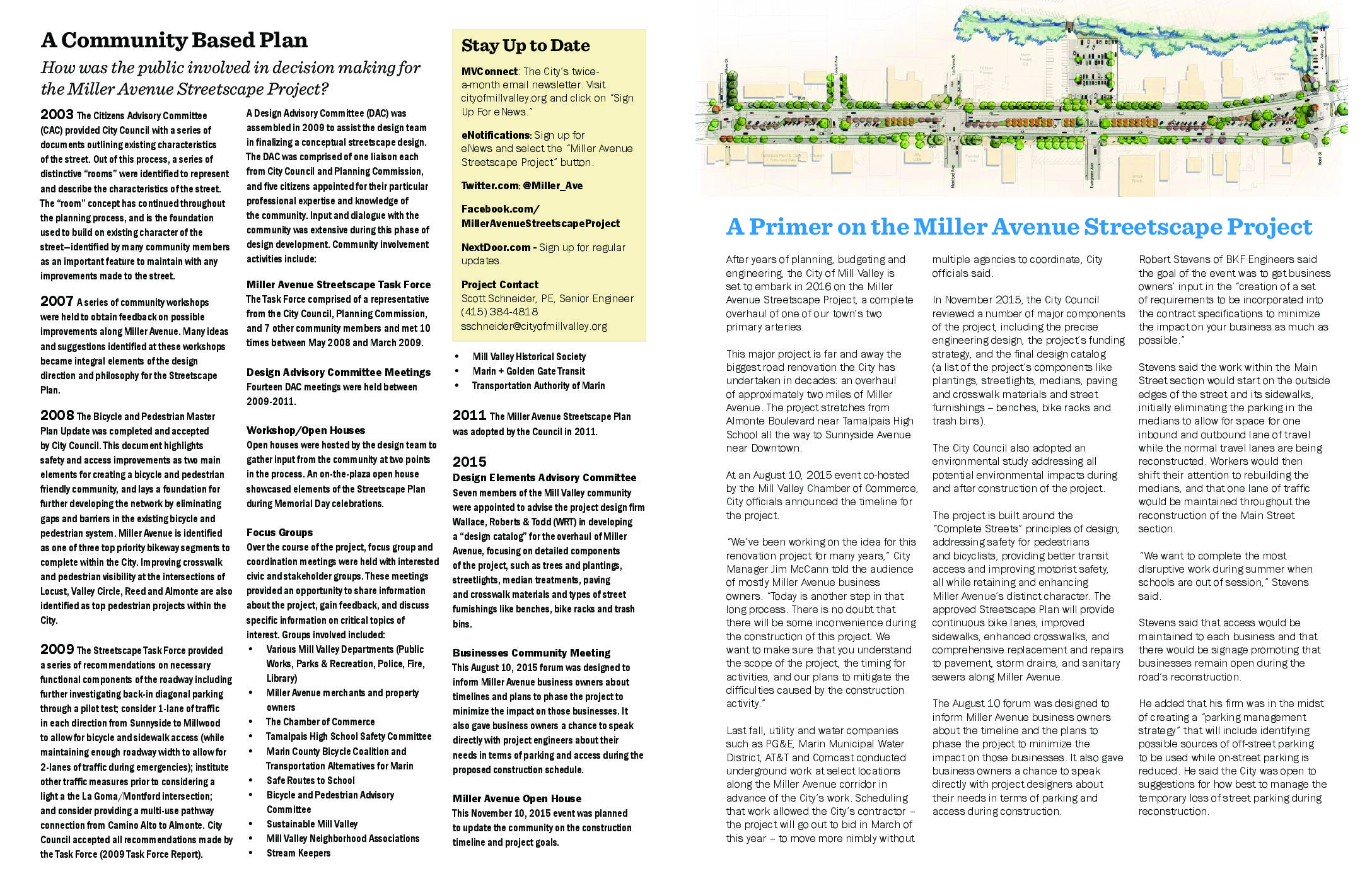
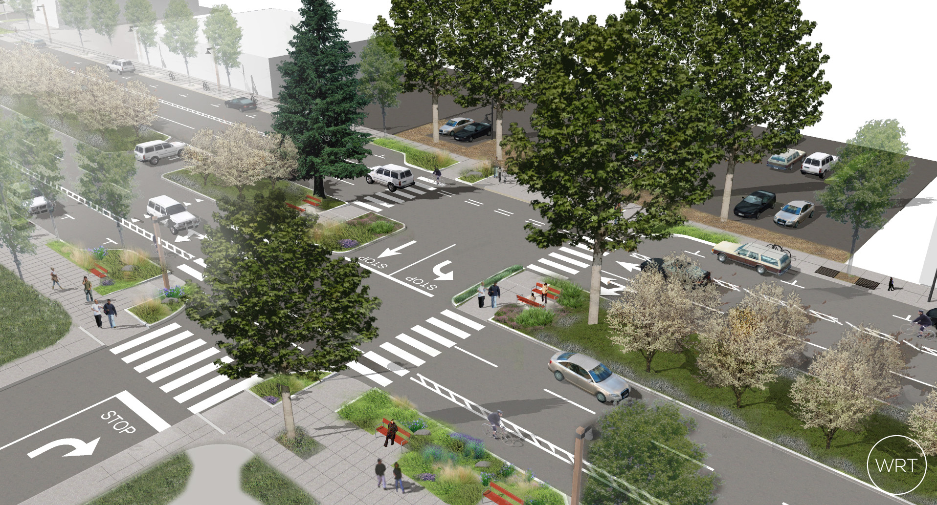
Miller Avenue functions as a central corridor serving the circulation, commerce, recreation, and experiential needs of Mill Valley. The Miller Avenue Streetscape Plan balanced a need to improve critical infrastructure and safety features while preserving the unique character of Mill Valley. The 2-mile thoroughfare is filled with unique character and five “rooms” that define the history of the street. The development of the Plan involved an extensive community-based planning process that incorporated multi-modal features along the corridor and highlighted historical conditions, surveyed community sacred places, identified minimal change options, evaluated existing trees and introduced water quality features to improve the quality of storm water released to the Corte Madera Creek Watershed. The Miller Avenue corridor was originally established with the railroad in 1889, leading to median parking to accommodate cars and the railroad. The Plan is the first comprehensive design for the street with a primary goal of creating a safe and efficient multi-modal corridor consistent with the Complete Streets principles of design, accommodating all users along the street including vehicles, transit, bicycles and pedestrians. The Plan also improved the underground and roadway infrastructure, preserve and enhance the corridor experience (through planting new drought resistant landscaping and rain gardens to reduce peak storm discharge into nearby creeks), maintain cultural features of Mill Valley, and improve the overall infrastructure. A 1,700 foot stretch of the Plan eliminated frontage roads, realigning the street to accommodate parking, travel lanes, accessible sidewalks and buffered bike lanes. Due to the large amount of reconstruction required, combined with challenging site conditions, the roadway construction underwent a process known as “Full Depth Reclamation” (FDR), pulverizing 18 inches of the underlying roadway that is then reused for ground materials and overlaid with new asphalt. FDR is 50% less expensive than traditional road repair methods, reducing excavation as well as the import and export of materials. The complete project improves traffic flow along Miller Avenue and established a multi-modal corridor following the principles of a Complete Street, and supports the Transportation Authority of Marin’s “Safe Routes to School” program. A new wooden boardwalk and sidewalk provides a pleasant walk along a creek to connect downtown Mill Valley to an adjacent residential neighborhood. At the other end of the corridor, a new pedestrian sidewalk and bridge replaced a social trail through sensitive wetland habitat to connect Miller Avenue to the popular Mill Valley-Sausalito Bay Trail. The project also includes a Class II bicycle lane for the full 2-mile length with most of the bicycle infrastructure providing a 3-foot bike buffer and 5 to 6-foot-wide bike lanes. Other safety and pedestrian improvements include the installation of several new
Add Comment