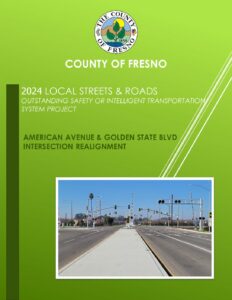
American Avenue and Golden State Boulevard Intersection Realignment
Location
American Avenue and Golden State Boulevard
City or County Responsible for Project
Fresno County
Category
Safety or Intelligent Transportation System Projects
Description
The intersection of Golden State Boulevard (GSB) and American Avenue had multiple design deficiencies, including horizontal and vertical alignment of the intersection and sight distance. These geometric deficiencies, together with the proximity to the Union Pacific Railroad (UPRR) tracks and the high-speed limits of the roadways (55 mph on American Ave and 65 mph on GSB), made it very challenging to design a major realignment along all four approaches. The skewed alignment of Golden State Boulevard as it crosses American Avenue created a non-standard intersection that was unsignalized and vehicles on American Avenue crossing GSB had to stop in the median to safely maneuver the crossing. There was also a 2.5 feet grade difference between the east leg of American Ave and the GSB which created a sight distance issue. These created a very unsafe condition for vehicles crossing this intersection and there were multiple fatalities before improvements were made to realign and signalize the intersection.
The site condition on the west side of the intersection provided less than 50 feet of stacking space (two passenger vehicles or one large tractor-trailer) for drivers waiting to cross or turn onto GSB. Additionally, the tight turn radii and narrow width of the existing configuration did not adequately allow truck traffic to make turning movements without encroaching on the opposing traffic lanes, thereby causing congestion and jeopardizing the safety of the motorists. On the east side, there was approximately 40 feet of stacking space between the westbound stop sign and the UPRR crossing which was not enough for even a single large tractor-trailer to stop between the stop sign and the UPRR tracks.
Westbound approaching traffic had to traverse an abrupt upslope followed by a down slope which caused a vertical grade difference of approximately 2.5 feet within a distance of 85 linear feet, to the stop sign on the east side of Golden State. That same space included a 100-foot-radius horizontal curve to the south which deflected the road nearly 45 degrees to become perpendicular to Golden State Blvd. Navigation of the intersection over the tracks was tricky because of the crest in the road at this location. Fast-moving cars lost contact with the ground and control of their vehicles and heavy trucks and tractor-trailers bottomed out their vehicle when crossing the tracks.
It took several years to initiate an agreement with UPRR and to obtain approval of the County’s project plans. The proximity of the GSB, the UPRR tracks, and Peach Ave just to the east of the intersection presented a unique challenge. In order to accomplish signalization of the intersection, preemption of the normal signal phasing during railroad crossings was provided in order to determine adequate queuing capacity, particularly for westbound traffic.
Improvements were made to raise the profile of GSB approximately 2.5 ft at the intersection to eliminate the abrupt change in elevation. The intersection was also straightened with the signalization and right and left turn pockets were added to improve the turn movements which creates a much safer and more efficient intersection for drivers.
Project submitted by
Name
Mohammad Alimi
Job Title
Design Engineer
Organization
County of Fresno
Address
2220 Tulare Street, 6th Floor
malimi@fresnocountyca.gov
Phone
559-600-4505